
Mount Whiteface, NH
via Blueberry Ledge, Rollins Trail, and Dicey Mill Trail
June 16, 2001
The 16th of June was an awfully tough hiking day. Hot, Hazy, and Humid do not make for enjoyable hiking conditions. I left home knowing the weather, but feeling confident that in the upper elevations of New Hampshire, the weather would not be so bad. I was prepared for the worst though with 33% more water than I normally carry.
The original plan was to do a loop and summit two mountains. Ascend Mount Whiteface via Blueberry Ledge and then take the Rollins Trail across a ridge and summit Mount Passaconaway via the Dicey Mill Trail. The return trip would be via Dicey Mill Trail back to the trail head. On paper, this looked like a fairly easy, but somewhat long day trip. I got a late start compared to normal (not making trailhead until around 9AM); however, was surprised by the low numbers of hikers (about a half dozen cars in the parking lot and a half dozen hikers just starting up with me).
The morning started off muggy; but not to bad. A light breeze was blowing in the valley. After a short stroll along a dirt road that led by some homes, the trail spilt from the road to the left. Immediately upon entering the trees and meeting the Blueberry Ledge trailhead, the flies attacked en masse. I had not used bug spray yet, just to see how bad the bugs would be. They were awful. After a head to toe covering of DEET, I was left alone for the most part. As I applied the coating of DEET, a group of three French speaking folk passed me.
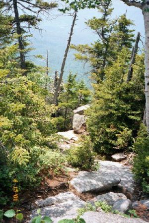
I started off at a brisk pace, in hopes of making a quick summit of Whiteface and gaining altitude to avoid the Hot, Humid air. This was folly on my part; on such a day, slow and steady wins the race. I quickly gained mid-mountain, where the trail winds in and out of the trees. Sometimes going deep into the brush and trees; and then opening up into the open on sheer rock surfaces. Often times, climbing steeply on both terrain features. Up hiking through the trees and coming to the wide open stretches of rock slab; a quick look behind me told the story of the day: The haze had locked the mountain in, and there would be not much to be had for views.
The French speaking folk and I passed each other often as we switched between taking breaks and plowing up the hill. I met up with an elder trio of experienced hikers; one lady having just finished the AT the year before. After a brief stretch of trail with them, I found their pace too slow for me, and I raced on along the trail.
|
|
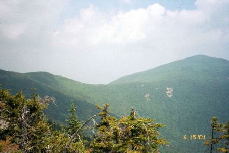
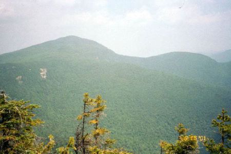
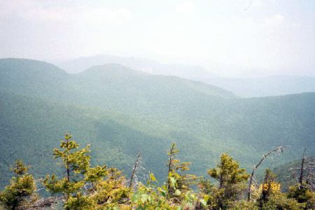
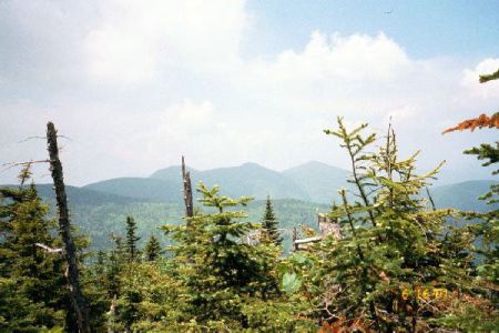
Nearing the summit, I was tiring quickly. The sun was beating down upon me as I passed into the wide open stretches, and the trees locked in the muggy, humid air when I ventured through the trees. Eventually, just below the ledges, things cooled off a bit and the haze broke up slightly. Just below the final 500 ft. of vertical, Mount Passaconaway can be seen to the north east, as well as the huge ravine that exists between Whiteface and Passaconaway as seen in the below pictures. The ravine was lush and green; an amazing landscape.
 |
 |
 |
 |
|
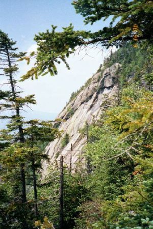
Just a short ways below the summit of Whiteface, are the Cliffs of the Blueberry Ledge Trail. These cliffs open up on the south side of the mountain and present some wide open vistas of the south facing valley. The trail winds up some small steep rock facings that require some hand holding and careful foot placement. Man made wooden steps used to be bolted into the granite cliffs to assist hikers, but have since been removed. I approve of this measure as it adds some challenge to the final 200 feet of elevation gain. The false summit of Whiteface provides a delightful southern viewing. The real summit of Whiteface is just a ways north along the Rollins Trail. After taking my shirt off and placing it on the rocks to hopefully dry the sweet and cool me off, I ate a quick lunch and hit the Rollins Trail heading towards Passaconnaway. The Rollins trail follows the rim of the natural bowl that is formed between Whiteface and Passaconnaway. The trail is essentially a roller coaster of a trail; going over several ups and downs, never staying flat for long, and ending lower than it begin. Along this trail, fatigue began to set in. I began to become hungry, but food made me want to throw up. I drank as much water as possible, but the water quenched no thirst. I stopped sweating and carried on with a bent back and heavy mind. On any other day, that trail probably would have seemed short and wonderful. But under the hot sun, I plodded on wanting it to end. I eventually came to the junction of the Rollins Trail and the Dicey Mill Trail. I made the wise choice not to make the 2 hour round trip to summit Passaconnaway as originally planned. After a long rest, I began plodding down the Dicey Mill Trail. The trail offered a very gradual and slow decent, featuring short descents followed by longer flats. After a mere 1.5 hours, I reached the parking lot, got into my car, and turned the air conditioner all the way up! |
Back To
Hiking New England
Comments? Suggestions? Your
Thoughts?
Email Them To: riverc0il@yahoo.com